region :: africa
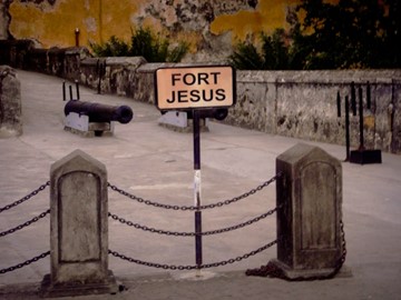
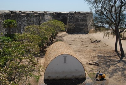
Fort Jesus
The Fort, built by the Portuguese in 1593-1596 to the designs of Giovanni Battista Cairati to protect the port of Mombasa, is one of the most outstanding and well preserved examples of 16th Portuguese military fortification and a landmark in the history of this type of construction. The Fort's layout and form reflected the Renaissance ideal that perfect proportions and geometric harmony are to be found in the human body. The property covers an area of 2.36 hectares and includes the fort's moat and immediate... Read More

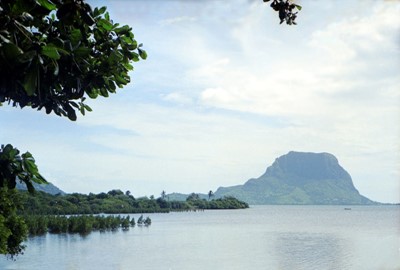
Mount Kenya
At 5,199 m, Mount Kenya is the second highest peak in Africa. It is an ancient extinct volcano, which during its period of activity (3.1-2.6 million years ago) is thought to have risen to 6,500 m. There are 12 remnant glaciers on the mountain, all receding rapidly, and four secondary peaks that sit at the head of the U-shaped glacial valleys. With its rugged glacier-clad summits and forested middle slopes, Mount Kenya is one of the most impressive landscapes in East Africa. The evolution and ecology of its ... Read More
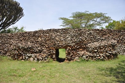
Thimlich Ohinga
Situated north-west of the town of Migori, in the Lake Victoria region, this dry-stone walled settlement was probably built in the 16th century CE. The Ohinga (i.e. settlement) seems to have served as a fort for communities and livestock, but also defined social entities and relationships linked to lineage. Thimlich Ohinga is the largest and best preserved of these traditional enclosures. It is an exceptional example of the tradition of massive dry-stone walled enclosures, typical of the first pastoral comm... Read More
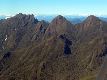
Tsingy de Bemaraha
Tsingy de Bemaraha Strict Nature Reserve comprises karstic landscapes and limestone uplands cut into impressive 'tsingy' peaks and a 'forest' of limestone needles, the spectacular canyon of the Manambolo river, rolling hills and high peaks. The undisturbed forests, lakes and mangrove swamps are the habitat for rare and endangered lemurs and birds.
Ambohimanga
The Royal Hill of Ambohimanga consists of a royal city and burial site, and an ensemble of sacred places. It is associated with strong feelings of national identity, and has maintained its spiritual and sacred character both in ritual practice and the popular imagination for the past 500 years. It remains a place of worship to which pilgrims come from Madagascar and elsewhere.
Rainforests of the Atsinanana
The Rainforests of the Atsinanana comprise six national parks distributed along the eastern part of the island. These relict forests are critically important for maintaining ongoing ecological processes necessary for the survival of Madagascar’s unique biodiversity, which reflects the island’s geological history. Having completed its separation from all other land masses more than 60 million years ago, Madagascar’s plant and animal life evolved in isolation. The rainforests are inscribed f... Read More
Lake Malawi
Located at the southern end of the great expanse of Lake Malawi, with its deep, clear waters and mountain backdrop, the national park is home to many hundreds of fish species, nearly all endemic. Its importance for the study of evolution is comparable to that of the finches of the Galapagos Islands.
Chongoni Rock Art Area
Situated within a cluster of forested granite hills and covering an area of 126.4 km2, high up the plateau of central Malawi, the 127 sites of this area feature the richest concentration of rock art in Central Africa. They reflect the comparatively scarce tradition of farmer rock art, as well as paintings by BaTwa hunter-gatherers who inhabited the area from the late Stone Age. The Chewa agriculturalists, whose ancestors lived there from the late Iron Age, practised rock painting until well into the 20th ce... Read More
Djenné
Inhabited since 250 B.C., Djenné became a market centre and an important link in the trans-Saharan gold trade. In the 15th and 16th centuries, it was one of the centres for the propagation of Islam. Its traditional houses, of which nearly 2,000 have survived, are built on hillocks (toguere) as protection from the seasonal floods.
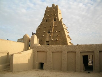
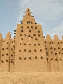
Timbuktu
Home of the prestigious Koranic Sankore University and other madrasas, Timbuktu was an intellectual and spiritual capital and a centre for the propagation of Islam throughout Africa in the 15th and 16th centuries. Its three great mosques, Djingareyber, Sankore and Sidi Yahia, recall Timbuktu's golden age. Although continuously restored, these monuments are today under threat from desertification.
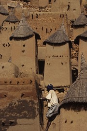
Bandiagara
The Bandiagara site is an outstanding landscape of cliffs and sandy plateaux with some beautiful architecture (houses, granaries, altars, sanctuaries and Togu Na, or communal meeting-places). Several age-old social traditions live on in the region (masks, feasts, rituals, and ceremonies involving ancestor worship). The geological, archaeological and ethnological interest, together with the landscape, make the Bandiagara plateau one of West Africa's most impressive sites.
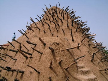
Tomb of Askia
The dramatic 17-m pyramidal structure of the Tomb of Askia was built by Askia Mohamed, the Emperor of Songhai, in 1495 in his capital Gao. It bears testimony to the power and riches of the empire that flourished in the 15th and 16th centuries through its control of the trans-Saharan trade, notably in salt and gold. It is also a fine example of the monumental mud-building traditions of the West African Sahel. The complex, including the pyramidal tomb, two flat-roofed mosque buildings, the mosque cemetery and... Read More
Aapravasi Ghat
In the district of Port Louis, lies the 1,640 m2 site where the modern indentured labour diaspora began. In 1834, the British Government selected the island of Mauritius to be the first site for what it called ‘the great experiment’ in the use of ‘free’ labour to replace slaves. Between 1834 and 1920, almost half a million indentured labourers arrived from India at Aapravasi Ghat to work in the sugar plantations of Mauritius, or to be transferred to Reunion Island, Australia, souther... Read More
Le Morne
Le Morne Cultural Landscape, a rugged mountain that juts into the Indian Ocean in the southwest of Mauritius was used as a shelter by runaway slaves, maroons, through the 18th and early years of the 19th centuries. Protected by the mountain’s isolated, wooded and almost inaccessible cliffs, the escaped slaves formed small settlements in the caves and on the summit of Le Morne. The oral traditions associated with the maroons, have made Le Morne a symbol of the slaves’ fight for freedom, their suffering, and ... Read More
Island of Mozambique
The fortified city of Mozambique is located on this island, a former Portuguese trading-post on the route to India. Its remarkable architectural unity is due to the consistent use, since the 16th century, of the same building techniques, building materials (stone or macuti) and decorative principles.
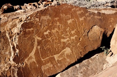
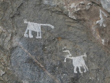
Twyfelfontein
Twyfelfontein or /Ui-//aes has one of the largest concentrations of [...] petroglyphs, i.e. rock engravings in Africa. Most of these well-preserved engravings represent rhinoceros, . The site also includes six painteelephant, ostrich and giraffe, as well as drawings of human and animal footprintsd rock shelters with motifs of human figures in red ochre. The objects excavated from two sections, date from the Late Stone Age. The site forms a coherent, extensive and high-quality record of ritual practices rela... Read More
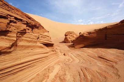
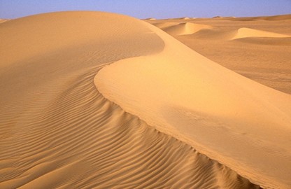
Namib Sand Sea
Namib Sand Sea is the only coastal desert in the world that includes extensive dune fields influenced by fog. Covering an area of over three million hectares and a buffer zone of 899,500 hectares, the site is composed of two dune systems, an ancient semi-consolidated one overlain by a younger active one. The desert dunes are formed by the transportation of materials thousands of kilometres from the hinterland, that are carried by river, ocean current and wind. It features gravel plains, coastal flats, ... Read More
Air and Ténéré
This is the largest protected area in Africa, covering some 7.7 million ha, though the area considered a protected sanctuary constitutes only one-sixth of the total area. It includes the volcanic rock mass of the Aïr, a small Sahelian pocket, isolated as regards its climate and flora and fauna, and situated in the Saharan desert of Ténéré. The reserves boast an outstanding variety of landscapes, plant species and wild animals.
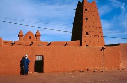
Agadez
Known as the gateway to the desert, Agadez, on the southern edge of the Sahara desert, developed in the 15th and 16th centuries when the Sultanate of Aïr was established and Touareg tribes were sedentarized in the city, respecting the boundaries of old encampments, which gave rise to a street pattern still in place today. The historic centre of the city, an important crossroads of the caravan trade, is divided into 11 quarters with irregular shapes. They contai... Read More

Sukur
The Sukur Cultural Landscape, with the Palace of the Hidi (Chief) on a hill dominating the villages below, the terraced fields and their sacred symbols, and the extensive remains of a former flourishing iron industry, is a remarkably intact physical expression of a society and its spiritual and material culture.
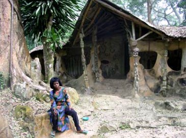
Osun Osogbo
The dense forest of the Osun Sacred Grove, on the outskirts of the city of Osogbo, is one of the last remnants of primary high forest in southern Nigeria. Regarded as the abode of the goddess of fertility Osun, one of the pantheon of Yoruba gods, the landscape of the grove and its meandering river is dotted with sanctuaries and shrines, sculptures and art works in honour of Osun and other deities. The sacred grove, which is now seen as a symbol of identity for all Yoruba people, is probably the last in Yoru... Read More
Djoudj National Bird Sanctuary
Situated in the Senegal River delta, the Djoudj Sanctuary is a wetland of 16,000 ha, comprising a large lake surrounded by streams, ponds and backwaters. It forms a living but fragile sanctuary for some 1.5 million birds, such as the white pelican, the purple heron, the African spoonbill, the great egret and the cormorant.
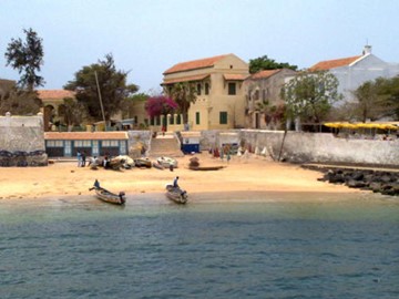
Island of Gorée
The island of Gorée lies off the coast of Senegal, opposite Dakar. From the 15th to the 19th century, it was the largest slave-trading centre on the African coast. Ruled in succession by the Portuguese, Dutch, English and French, its architecture is characterized by the contrast between the grim slave-quarters and the elegant houses of the slave traders. Today it continues to serve as a reminder of human exploitation and as a sanctuary for reconciliation.
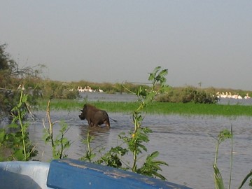
Niokolo Koba
Located in a well-watered area along the banks of the Gambia river, the gallery forests and savannahs of Niokolo-Koba National Park have a very rich fauna, among them Derby elands (largest of the antelopes), chimpanzees, lions, leopards and a large population of elephants, as well as many birds, reptiles and amphibians.

Island of Saint Louis
Founded as a French colonial settlement in the 17th century, Saint-Louis was urbanised in the mid-19th century. It was the capital of Senegal from 1872 to 1957 and played an important cultural and economic role in the whole of West Africa. The location of the town on an island at the mouth of the Senegal River, its regular town plan, the system of quays, and the characteristic colonial architecture give Saint-Louis its distinctive appearance and identity.